
Mount Silali – Kenya’s Silent Giant of the Northern Rift Valley
- maria maris
- Nov 12, 2025
- 4 min read

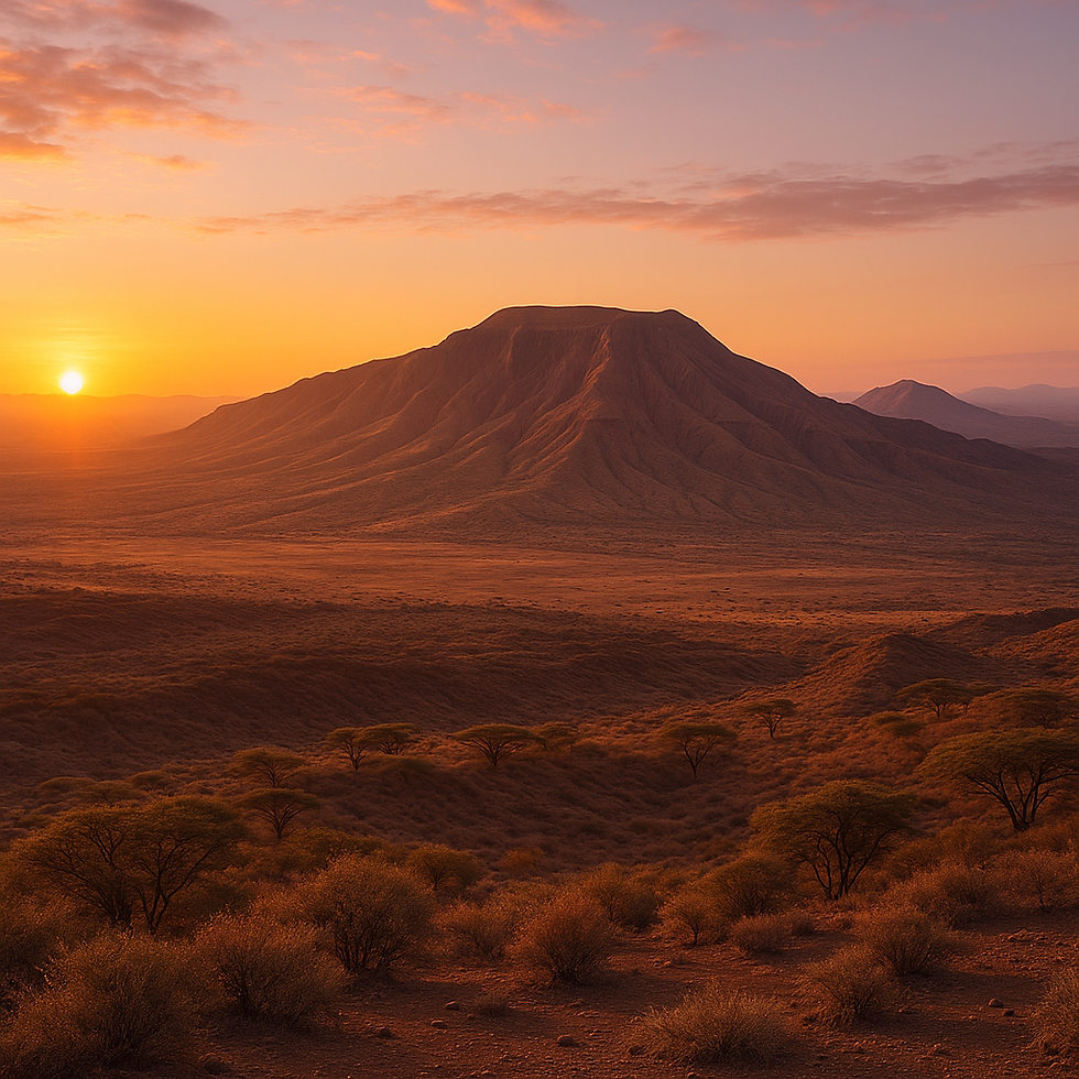
Rising from the vast and remote landscapes of northern Kenya, Mount Silali is one of the country’s most impressive yet least explored volcanic mountains. Located in the northern section of the Great Rift Valley, Silali stands as a silent giant — a massive extinct caldera surrounded by rugged lava fields, dramatic cliffs, and a harsh but stunning desert-like environment.
Although few travelers make it to this part of Kenya, Mount Silali is a geological wonder, an adventure frontier, and a powerful symbol of the forces that shaped East Africa millions of years ago.

Where Is Mount Silali Located?
Mount Silali is located in West Pokot County, near the borders of Turkana and Baringo counties. It lies roughly:
80 km northeast of Kapedo
130 km from Maralal
300+ km north of Nakuru
It sits within the northern Kenya volcanic chain, together with Mount Kulal, Mount Nyiro, Mount Paka, and Mount Korosi — each part of a colossal geological system created by rifting and volcanic activity.
A Massive Extinct Volcano
Geologists identify Silali as one of Kenya’s largest calderas. The volcano collapsed thousands of years ago, leaving behind:
A circular caldera about 7 km wide
Steep, rocky crater walls rising above the surrounding plains
Ancient lava flows stretching for kilometers in all directions
Numerous volcanic cones and ash fields
Unlike Mount Kenya or Mount Elgon, Silali is not covered with forests or alpine vegetation. Instead, its raw, semi-arid environment offers a unique and almost otherworldly beauty.
Today, Mount Silali is considered extinct, with no recorded eruptions in recent history, though geothermal activity exists in the broader Rift region.
Landscape and Scenery
Silali’s region is one of the most rugged and untouched landscapes in Kenya. Travelers will encounter:
Black lava fields spreading across the valley floor
Volcanic ridges and cliffs with layered ash
Cactus and acacia vegetation scattered across dusty plains
Seasonal riverbeds cutting through volcanic rock
Wide desert horizons that glow beautifully during sunrise and sunset
The caldera itself is dramatic — a massive bowl-like depression where cliffs drop sharply to the flat interior floor. It feels remote, isolated, and breathtakingly wild.
Wildlife Around Silali
Though not a typical wildlife reserve, the region hosts hardy desert and savanna species that have adapted to the dry conditions:
Grevy’s zebra
Beisa oryx
Grant’s gazelle
Gerenuk
Kudu
Rock hyrax
Bird species include:
Ostriches roaming open plains
Vultures circling volcanic cliffs
Kori bustards walking across the scrublands
Around seasonal water points, herders often bring camels, which add to the region’s cultural and desert-like charm.
Communities and Culture
Mount Silali lies in the traditional lands of the Pokot, Turkana, and Samburu communities. In these remote areas, visitors may encounter:
Traditional pastoralist lifestyles
Colorful beadwork and cultural attire
Camel and goat herding
Ancient stories about mountains and spirits
Local guides often share cultural narratives about Silali, including legends of the mountain’s formation and the deep respect people have for the land.
What to Do at Mount Silali
1. Hiking to the Caldera Rim
Adventurers can trek up the outer slopes to reach the dramatic caldera rim. From the top, the crater spreads out below like a gigantic natural amphitheater. Views stretch endlessly across volcanic plains, making it perfect for photography.
2. Geological Exploration
Volcano enthusiasts can explore:
Old lava tubes
Ash cliffs
Volcanic cones
Steam vents in surrounding geothermal zones
It’s a living classroom for anyone fascinated by Earth’s tectonic forces.
3. Camel or 4x4 Desert Expeditions
Because roads are rough, many travelers explore the region using:
Camel caravans with local guides
Off-road 4x4 vehicles
These expeditions offer a true sense of wild, frontier travel.
4. Cultural Visits
Nearby Pokot and Turkana communities often welcome visitors interested in learning about traditional pastoralist culture.
Climate and Best Time to Visit
Mount Silali lies in one of the hottest and driest parts of Kenya. Expect:
High daytime temperatures (30–38°C)
Cool nights
Minimal rainfall
Occasional dramatic storms during wet seasons
Best time to visit:
June to September
December to February
These months offer mild temperatures and clearer skies.
How to Get There
Reaching Mount Silali requires planning and strong vehicles:
4x4 vehicle mandatory
Routes through Maralal, Kapedo, or Lodwar region
Travel best done with a local guide
Fuel and supplies should be carried in advance
Because of its remoteness, Silali is recommended for experienced adventure travelers.
Accommodation
There are no established lodges or hotels around Mount Silali. Options include:
Wild camping near the volcano
Staying in nearby small towns like Kapedo, Chemolingot, or Barpello
Community-run campsites in some areas
Travelers must bring their own camping equipment and enough water and food.
Scientific and Conservation Importance
Mount Silali lies within the Northern Rift geothermal zone. Scientists study the region for:
Volcanic history
Rift valley tectonics
Geothermal energy potential
This data helps understand East Africa’s geological evolution and energy resources.
The area also supports vulnerable ecosystems, and conservation efforts aim to balance wildlife protection with pastoralist livelihoods.
Why Visit Mount Silali
Mount Silali is not a typical tourist destination — it's raw, remote, and wonderfully untouched. What makes it special is the feeling of being on the edge of the world:
Towering volcanic walls
Endless plains
Crisp desert silence
Ancient geological history
A sense of pure adventure
For explorers, photographers, volcanologists, and anyone seeking the true spirit of wild Kenya, Silali is a destination that leaves an unforgettable mark.


Comments